
It is time for us to see a different Bolivia. We depart from an anonymous Capital city of LaPaz,
enclosed in a basin between huge mountain ranges . We ride south-bound along the Carretera 5 toward Oruro, ( city skeleton ), then to Challapata, where we take the direction of Quillas. That will take us to the northern entrance of the Salar de Uyuini. The road presents itself immediately fascinating in its landscaping. Alpacas and Lamas are grazing on arid soils.
The terrain we ride on show a strong desalinization due to the continuous drainage of the lakes that were massive here once upon a time.
The road we ride on allows us to keep a pretty good speed. We are riding on a plateau
surrounded by high mountain ranges with dry desert vegetation worthy of a
leg of the famous Paris-Dakar race. That is probably why, that near Salinas Garci Mendoza we met 2 official 4X4 trucks from the organization of the Dakar. They are here to map the 2014 edition that for the first time will be held also in Bolivia after Chile and Argentina.


The road we are riding next is made mostly of sand, salt, and rocks. It is the gateway to the Salar de Uyuni. In front of us the volcano Tunupa ( 5400mt ) is showing its majestic predominance.
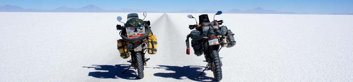
The entrance to the Salar will leave us immediately struck dumb for the extraordinary
environment in which we are. As we continue, we struggle to distinguish the gap between the white expanse of salt and the blue sky. This is due to the fact that the sun light reflects on this immense white platform and it gives us the impression of riding on a cloud.


For about 160 km we will cross the Salar with an absolute freedom. First paired and close to one another, then separate to the point to discern only a dark dot in the distance. We reach the Isla de Pescado first and the Isla Inca Huasi then. The characteristics of these islands are those to be covered by a multitude of cactus.

 The transfer from the Salar to the area of the lagoons will be fairly easy but
from San Cristobal, we ride into a landscape formed initially by
several streams and all of a sudden an area mostly deserted with only
Quinoa cultivation. Along the way, we encounter small villages built with
mud bricks and thatched roofs.


Up to Villa Mar the environment will be ‘ completely deserted with a vague
similarity to the African savannahs where only a few threads of Alpacas and lonely
desert foxes give some signs of life !
From Villa Mar onward, the road condition changed. It takes us to 4700 mt along a really rough bottom
of stony ground until opening on a lagoon that will leave us speechless. From now on, every turn will find a glimpse of the most beautiful scenery encountered so far. It gives us a feeling of driving inside a National Geographic documentary.

Due to a very challenging ride, we will arrive exhausted to the shelter of the lagoon late in the evening. We are so exited to be here and we feel extremely fortunate to have made it to this magical place. This is truly a unique area in the world and certainly not an easy one to achieve with our motorcycles.


 After passing the night with an outside temperatures of -18, the plan is to reach the Chilean border. Sand, stones, ice, and freezing temperatures will be accompanying us for most of the time and will not be enough to erase the smiles and beautiful memories that this region has given us. The altitude on my GPS now shows 16,200 feet above sea level.
The boundary of Hito Cajones approaches but there will be ‘ more time to admire
Laguna Celeste, Laguna Verde and Laguna Colorada. These roads will remain
forever in our memory.


Here we go now. We have reached this small border crossing between Bolivia and Chile. The small building is surrounded by huge mountains. We are at 4,400mt, icy winds can be felt under our heavy motorcycle gear. The only custom official let us quickly exit Bolivia to take the easy road to San Pedro d’Atacama in Chile. As we ride downhill we continue to look up and thanks those mountains for the numerous feelings they were able to give us through this segment of our journey.


